
Keyword
PANACeA project
27 record(s)
Type of resources
Available actions
Topics
Keywords
Contact for the resource
Provided by
Years
Formats
Representation types
Update frequencies
Status
Scale
panaceaKeywords
GEMET keywords
-
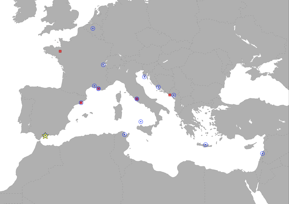
The layer shows type and location of partners involved in PANACeA project. PANACeA is an Horizontal Project of the biodiversity protection community funded by the Interreg Med Programme. The PANACeA MPAs project deals with streamlining networking and management efforts in Mediterranean protected areas for enhanced natural conservation and protection.
-
%20partners.PNG)
The layer shows type and location of partners involved in the Biodiversity Protection Project . The BBP is an Horizontal Project of the biodiversity protection community funded by the Interreg Med Programme. The BPPproject deals with streamlining networking and management efforts in the Mediterranean region for enhanced natural conservation and protection.
-

The Marine Protected Area Protection Framework (MaPAF; Rodríguez-Rodríguez et al., 2016) was adapted to update progress on the protection of Pelagos Sanctuary marine biodiversity. Accordingly, protection was conceived as an additive process entailing two complementary factors: 1. Legal protection and 2. Managerial protection. Legal protection was assessed through two indicators: 1.1. Legal designation (this specific layer), contributing to protection coverage targets, and 1.2. Regulation stringency, contributing to strict protection targets. Managerial protection was assessed via two indicators: 2.1. Existence of a management authority for the site, and 2.2. Existence of a management plan that is fully implemented. Both indicators are expected to contribute to effective Marine Protected Areas & Other Effective Area-Based Conservation Measures (OECMs) management targets. Thus, a site can be legally protected (typically, an MPA), by management measures (e.g. an OECM), attaining different degrees of conservation to their biodiversity. Therefore, a site that has been endowed a stringent legal designation category which has an appointed managerial authority that fully implements the site’s management plan is assumed to have greater protection than a site with opposite characteristics.
-
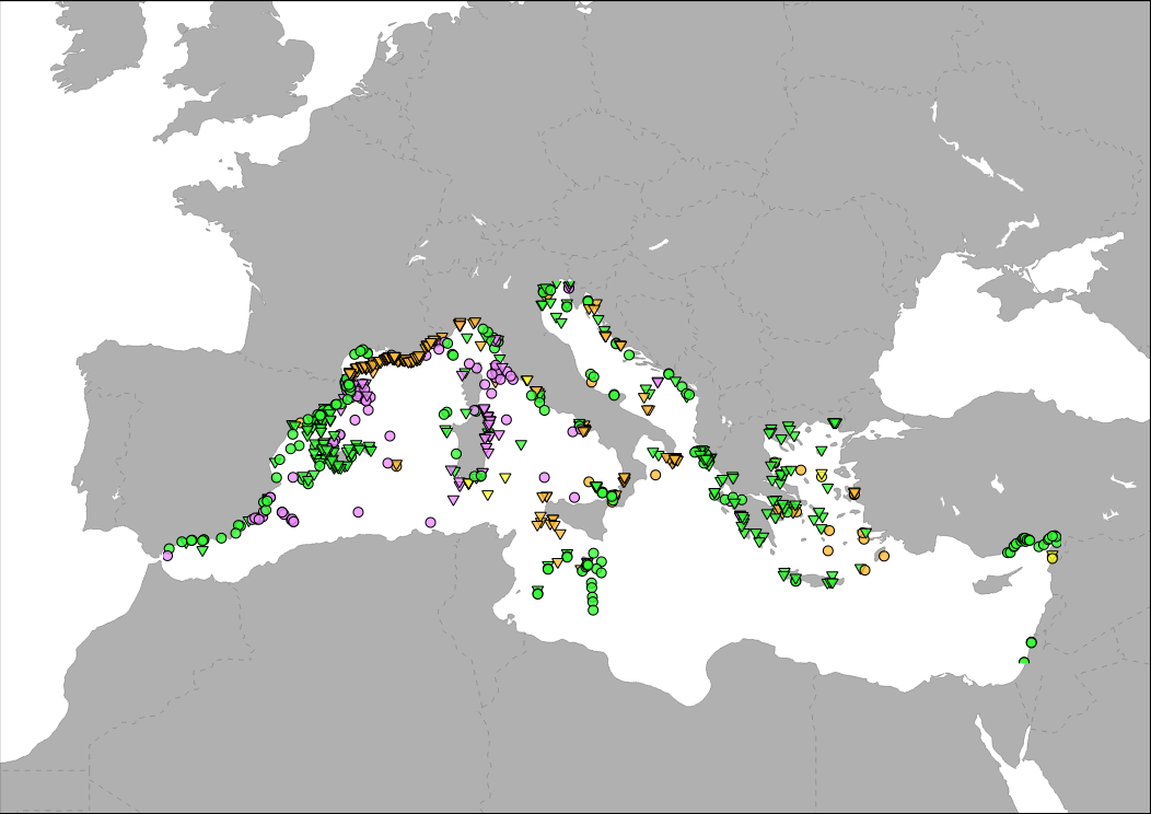
Medbiolitter database summarises results of scientific studies on biodiversity and marine litter interactions in the Mediterranean Sea. To this end, information is collected from different data sources, such as institutions or projects, as well as peer-reviewed publications. The main source of data currently is LITTERBASE/AWI, including only the coverage within the Mediterranean. The database currently comprises 754 records on interactions. Interaction refers to encounters between wildlife and litter items and are classified in four categories: 1) Ingestion, which is the most frequently observed interaction, followed by 2) entanglement, which affects motility, often with fatal consequences, 3) colonization, which occurs when many species settle on floating litter, and 4) others, including different types of less frequent interaction. The database includes among others the location, the type of interaction and litter, marine realm (beach, sea surface, water column, seafloor), habitat, species, whether it occurs in a marine protected area and the type in such case, as well as references to the publication from which the data are extracted. The layer is represented in different ways in the MED Biodiversity platform: 1) Marine litter and biodiversity interactions: it shows the database by type of interaction (ingestion, entanglement, colonization and other) and marine realm (pelagic or benthic). 2) Knowledge update: changes in the number of records in each database version. It tries to represent the efforts of the PANACeA project to gather additional information on the Mediterranean Sea. 3) Marine litter knowledge from 1988 to present date: shows the years of publication of the source of the records in the database. In recent dates, especially since 2015, there has been a notable increase in the number of publications related to marine litter.
-
The Marine Protected Area Protection Framework (MaPAF; Rodríguez-Rodríguez et al., 2016) was adapted to update progress on the protection of Pelagos Sanctuary marine biodiversity. Accordingly, protection was conceived as an additive process entailing two complementary factors: 1. Legal protection and 2. Managerial protection. Legal protection was assessed through two indicators: 1.1. Legal designation, contributing to protection coverage targets, and 1.2. Regulation stringency, contributing to strict protection targets. Managerial protection was assessed via two indicators: 2.1. Existence of a management authority for the site, and 2.2. Existence of a management plan that is fully implemented (this layer). Both indicators are expected to contribute to effective Marine Protected Areas & Other Effective Area-Based Conservation Measures (OECMs) management targets. Thus, a site can be legally protected (typically, an MPA), by management measures (e.g. an OECM), attaining different degrees of conservation to their biodiversity. Therefore, a site that has been endowed a stringent legal designation category which has an appointed managerial authority that fully implements the site’s management plan is assumed to have greater protection than a site with opposite characteristics.
-
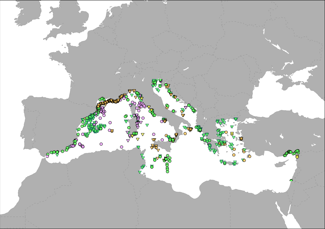
Medbiolitter database summarises results of scientific studies on biodiversity and marine litter interactions in the Mediterranean Sea. To this end, information is collected from different data sources, such as institutions or projects, as well as peer-reviewed publications. One of the main sources of data is LITTERBASE/AWI, only including the coverage within the Mediterranean Sea. The database currently comprises 1056 records on interactions. Interaction refers to encounters between wildlife and litter items and are classified in four categories: 1) Ingestion, which is the most frequently observed interaction, followed by 2) entanglement, which affects motility, often with fatal consequences, 3) colonization, which occurs when many species settle on floating litter, and 4) others, including different types of less frequent interaction. The database includes among others the location, the type of interaction and litter, marine realm (beach, sea surface, water column, seafloor), habitat, species, whether it occurs in a marine protected area and the type in such case, as well as references to the publication from which the data are extracted.
-
Medbiolitter database summarises results of scientific studies on biodiversity and marine litter interactions in the Mediterranean Sea. To this end, information is collected from different data sources, such as institutions or projects, as well as peer-reviewed publications. One of the main sources of data is LITTERBASE/AWI, only including the coverage within the Mediterranean Sea. The database currently comprises 918 records on interactions. Interaction refers to encounters between wildlife and litter items and are classified in four categories: 1) Ingestion, which is the most frequently observed interaction, followed by 2) entanglement, which affects motility, often with fatal consequences, 3) colonization, which occurs when many species settle on floating litter, and 4) others, including different types of less frequent interaction. The database includes among others the location, the type of interaction and litter, marine realm (beach, sea surface, water column, seafloor), habitat, species, whether it occurs in a marine protected area and the type in such case, as well as references to the publication from which the data are extracted.
-
Medbiolitter database summarises results of scientific studies on biodiversity and marine litter interactions in the Mediterranean Sea. To this end, information is collected from different data sources, such as institutions or projects, as well as peer-reviewed publications. The main source of data currently is LITTERBASE/AWI, including only the coverage within the Mediterranean. The database currently comprises 903 records on interactions. Interaction refers to encounters between wildlife and litter items and are classified in four categories: 1) Ingestion, which is the most frequently observed interaction, followed by 2) entanglement, which affects motility, often with fatal consequences, 3) colonization, which occurs when many species settle on floating litter, and 4) others, including different types of less frequent interaction. The database includes among others the location, the type of interaction and litter, marine realm (beach, sea surface, water column, seafloor), habitat, species, whether it occurs in a marine protected area and the type in such case, as well as references to the publication from which the data are extracted.
-
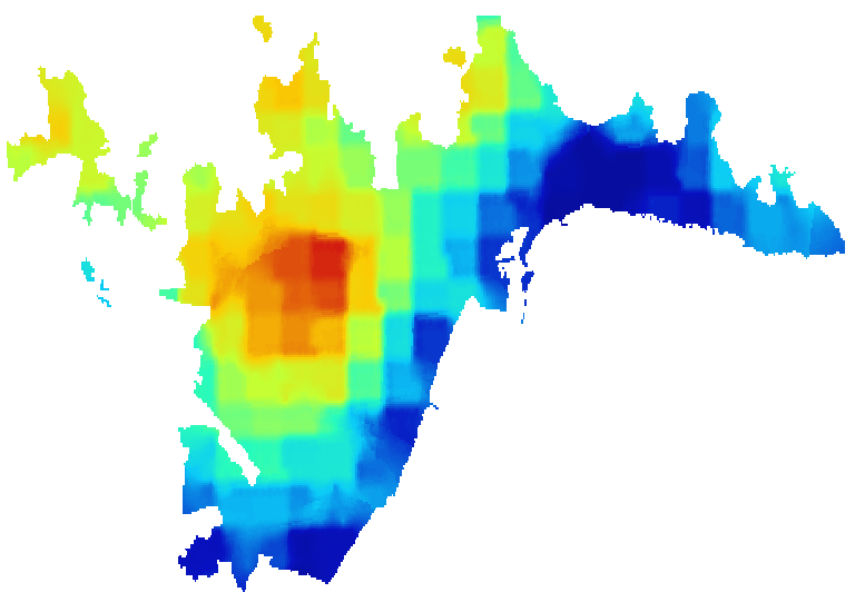
Representación del efecto Isla de Calor Urbana mediante la oscilación térmica media anual diurna por grandes barrios en la ciudad de Málagadesde 2003 a 2023. Para la elaboración de la presente información se han utilizado datos MODIS para el cálculo de la diferencia de temperatura entre área urbana y áreas colindantes. Concretamente se utilizan los datos LST (el término "LST" en el contexto de MODIS se refiere a "Land Surface Temperature" en inglés, que significa "Temperatura de la Superficie Terrestre" en español) derivados de MODIS de TERRA (MOD11A2) y AQUA (MYD11A2), disponibles con una resolución de 1000 m × 1000 m. Solo se procesan los píxeles con cielo despejado (nubosidad 0%) para no meter ruido en los cálculos de medias de temperatura. La franja horaria diurna analizada comprende desde las 13:30 a las 22:30 horas, recopilando datos desde el 2003 hasta el 2023 (20 años). En este caso, se ha realizado la diferencia en LST de los píxeles urbanos y los píxeles no urbanos dentro de una extensión urbana, en este caso la definida como entorno urbano de Málaga. Los datos de la capa pueden utilizarse para identificar las áreas urbanas que son más propensas a experimentar el efecto isla de calor en la Ciudad de Málaga.
-
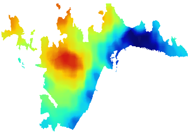
Representación del efecto Isla de Calor Urbana mediante la oscilación térmica media estival diurna por grandes barrios en la ciudad de Málaga desde 2003 a 2023. Para la elaboración de la presente información se han utilizado datos MODIS para el cálculo de la diferencia de temperatura entre área urbana y áreas colindantes. Concretamente se utilizan los datos LST (el término "LST" en el contexto de MODIS se refiere a "Land Surface Temperature" en inglés, que significa "Temperatura de la Superficie Terrestre" en español) derivados de MODIS de TERRA (MOD11A2) y AQUA (MYD11A2), disponibles con una resolución de 1000 m × 1000 m. Solo se procesan los píxeles con cielo despejado (nubosidad 0%) para no meter ruido en los cálculos de medias de temperatura. La franja horaria diurna analizada comprende desde las 13:30 a las 22:30 horas, recopilando datos de los meses de junio, julio y agosto desde el 2003 hasta el 2023 (20 años). En este caso, se ha realizado la diferencia en LST de los píxeles urbanos y los píxeles no urbanos dentro de una extensión urbana, en este caso la definida como entorno urbano de Málaga. Los datos de la capa pueden utilizarse para identificar las áreas urbanas que son más propensas a experimentar el efecto isla de calor en la Ciudad de Málaga.